


 24/7 Emergency Service
Fire Drought Danger
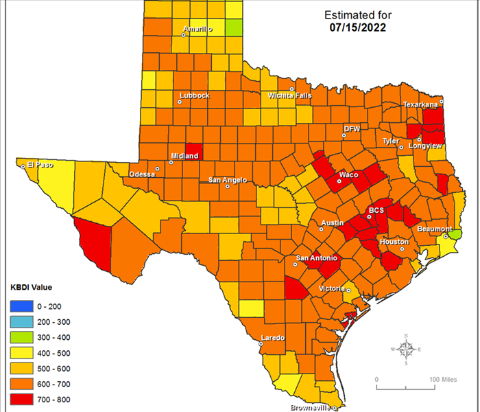
7/15/2022 (Permalink)
 Keetch-Byram Drought Index
High KBDI values indicate that conditions are favorable for the occurrence and spread of wildfires. The following table shows how KBDI and expected fire potential relate.
KBDI ValuesDrought and fire potential information 0 – 200Soil and fuel moisture are high. Most fuels will not contribute much to wildfire intensity. This is often seen in spring after winter precipitation. 200 - 400Fuels are beginning to dry and contribute to wildfire intensity. Heavier fuels will still not readily ignite and burn. This is often seen in late spring. 400 - 600Wildfire intensity begins to increase significantly. Wildfires will readily burn, and larger fuels could burn or smolder for several days. This is often seen in late summer and early fall. 600 - 800Wildfires will show extreme intensity. Deep-burning, intense wildfires with significant spotting can be expected. This is often associated with severe drought.
Presently, this index is derived from ground-based estimates of temperature and NEXRAD radar of precipitation derived from weather stations and interpolated manually by experts at Texas A&M Forest Service for counties across the state. Researchers at Texas A&M University are working with TFS to derive this index from NOAA National Weather Service data and NEXRAD radar rainfall within a GIS.